Soil Use and Conservation

Everything here revolves around the topic of soil. We research and develop new methods and criteria for evaluating and mapping soil properties, with the aim of using soils more effectively and protecting them more efficiently.

Our expertise lies in the development of methods for collecting, analysing, managing, and sharing information about soil. We use new technologies in a targeted way to complement existing methods. In the ongoing revision of the classification and mapping guidelines for Swiss soils, we pool our knowledge to develop future-proof solutions. Interdisciplinary cooperation is also one of our hallmarks: we work very closely with other BFH-HAFL research groups, because soil is a key component in many issues.

Services + Expertise

  • Compilation of references for soil descriptions and assessment
  • Support with digitalisation processes and data management
  • Statistical data analysis, spatial modelling of soil properties and development of pedotransfer functions using classical (geo-)statistics or machine learning methods
  • Geodata visualisation and development of web app prototypes
  • Analysis of the causes of soil erosion and search for solutions
  • Pedological field assessments and laboratory analysis of chemical and physical soil properties
  • Soil-specific impact monitoring of measures taken
  • Drone photography and solution-oriented analysis of drone and satellite images
  • Practice-oriented teaching – from primary school to MSc levels – teaching of soil science field methods, and continuing education courses (agriculture, soil mapping)

Infrastructure

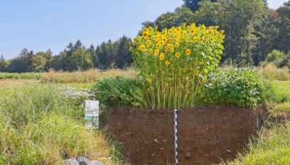
Anybody interested in our permanent soil profiles is welcome to visit us on campus.

We have soil science field equipment, a laboratory, and teaching and display materials.

We are happy to lend our materials to schools and provide tips on how to address the topic of soil in the classroom.

Projects

The organic soils in the Rhine Valley are an invaluable foundation for agricultural production. But at the same time, their fertility is threatened by the breakdown of organic matter. Detailed spatial information on the properties of the organic soils in the Rhine Valley is required for making locally adapted and hence potentially successful soil improvements. Because large land areas are involved, new mapping methods must be developed. The objectives of the project are:

  • Development of a mapping methodology that will enable efficient mapping of organic soils heavily impacted by human activity. This requires adaptation of the existing methods and clear definition of the goals.
  • Development of technology for recording field images that will permit the high drilling density required for peat soils, and development of methods for analysing these images.
  • Development of an efficient information processing system for long-term storage of all collected data and for quality assurance.
  • Analysis of current and future fertility problems in peat soils.

Soil maps describe the spatial distribution of soil properties as well as the soil functions arising from them in a given terrain. In Switzerland there is a great need for spatial soil information for numerous applications. Most user groups require detailed maps (for example on a scale of 1:5000) of the entire land area of interest to them. Furthermore, the strategy of the Swiss Federal Office for the Environment (BAFU) stipulates that soil consumption and use should be guided by soil information. In this project, we explore the following questions:

  • In terms of both content and information density, specifically what soil information is required in the Canton of Bern?
  • Are the sought-after soil properties and functions adequately reflected in the Swiss soil classification scheme?
  • To what extent can technological innovations can be integrated in the mapping process and how can we make the most of already existing soil and geological data?
  • What priorities should be followed with respect to mapping sequence, precision and content?
  • What cost-benefit ratios are associated with the individual soil properties, soil functions and soil information density?

The Humus Resources Programme (Ressourcenprogramm Humus) aims to raise awareness among farmers regarding the topic of humus management. Farmers can use simple indicators and methods, e.g., humus content measurement or the spade test, as tools for monitoring changes directly in the field. Humus balance has recently become established (at least in research) as a further, indirect indicator for managing humus on a farm. The goals of this project are:

  • To measure the organic matter content in a field, in order to determine the direct impact of the measures.
  • To identify difficulties and shortcomings in the use of the humus balance tool.
  • To rate acceptance of the humus-building measures in comparison with their benefits.
  • To identify which measures are preferably implemented. Modelling the changes with the humus balance tool. Problems, innovation and exchange will be dealt with in the context of discussions within the working group.

The potential of new data such as satellite and drone images for detailed soil mapping seems very promising. However, the added value thereof has yet to be demonstrated. In this pilot project, we plan to examine the following questions in conjunction with actual soil mapping:

  • Is the use of drones for soil mapping helpful in the different project phases? If so, in which ones?
  • Does drone use improve soil maps (data quality, clarity)? In particular, are reclaimed and recultivated areas more easily or more effectively mapped with drone support? Can polygon boundaries be established more precisely?
  • Does using drones cut back on costs?
  • Would drones be useful for assessing crop rotation areas?

The soils topic is well suited as content for illustrative teaching units in the STEM (science, technology, engineering and mathematics) area. In this collaborative project with the University of Teacher Education Bern (PH Bern), we are presenting this topic and demonstrating potential teaching content and experiments to prospective teachers. We also serve as contacts for the teachers when it comes to planning teaching units on soil. The creation of a soil profile constitutes a key element for the primary school, secondary school I and II levels. We also prepare more advanced instructional material adapted to the respective levels.

Zwischen 2019 und 2025 wird die Methodik rund um die Klassifikation und Kartierung der Böden der Schweiz überarbeitet. Hier finden Sie alle Informationen zum Projekt:

la mise en valeur des données pédologiques anciennes a été effectuée pour les canton de VD, GE et Fribourg. Les projet suivants appartiennent à cette problématique.

Canton de VD: Projet de valorisation des données pédologiques historique s dans le canton de Vaud

Mise en valeur des données pédologiques de Michel Gratier: calibration des données, modélisation de paramètres tels que profondeur, texture, calcaire, validation indépendantes à l’aide de 500 points répartis dans 5 zones dans tout le canton.

  • Durée du projet/Projektlaufzeit: 2019-2022
  • Mandant / Auftraggeber: Canton de Vaud, Division géologie, sols et déchets (GEODE) et Direction générale du territoire et du logement (DGTL)
  • Personne de contact / Kontaktperson: Stéphane Burgos

Canton de GE: Projet de valorisation des données pédologiques historique dans le canton de Genève

digitalisation des anciens sondages papiers, vérification de 200 pour la calibration des description, modélisation des paramètres tels que profondeur, texture, calcaire, validation indépendantes avec 200 points.

Canton de Fribourg: Projet d’évaluation de la diversité pédologique du canton de Fribourg

200 sondages pédologiques seront effectués aux emplacement du réseau d’observation FRIBO pour documenter le type de sol et l’adéquation avec les cartes géologiques et la forme du relief.

  • Durée du projet/Projektlaufzeit: 2022
  • Mandant / Auftraggeber: Service de l'environnement Sen, Section EIE, sol et sécurité des installations
  • Personne de contact / Kontaktperson: Stéphane Burgos
  • Projektinformationen

Team & Contact

Are you interested in working with us or would you like to know more about our research in soil use and conservation? Please contact us.